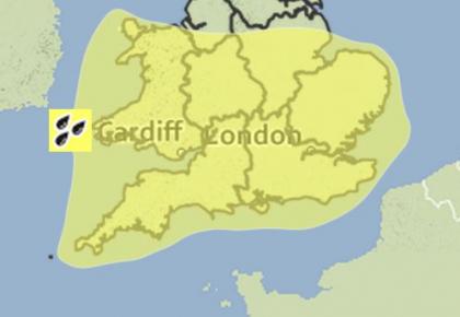


Thunderstorms expected across Devon
Thunderstorms are expected throughout Devon today as the Met office issue a weather warning.
Forecasters predict that areas of heavy and locally thundery rain will move north and west across the southern half of England along with Wales during the early hours of Thursday morning.
A brief period of drier weather reaching the extreme southeast around midnight Thursday will follow northwestwards, probably reaching much of Wales and southwest England later in the morning.
But cattered locally heavy showers, with the risk of some slow-moving thundery downpours, are likely to develop quite quickly during Thursday, only slowly dying out in the evening.
A Chief Forecaster for the Met Office said: “An active complex frontal zone is expected to move northwards into southeast England on Wednesday evening continuing across the southern half of England and Wales on Wednesday night into Thursday morning.
“This brings the threat of some heavy rain for a time with embedded convection within the frontal band. To the rear of the frontal zone scattered thundery showers are likely to develop bringing some further localised downpours during Thursday afternoon.
“Considerable local variations in rainfall are likely. However, totals of more than 40 mm are likely in places through the day with a risk of 15 mm falling in less than an hour locally.”
Forecasters have warned that the public should be aware of the risk of localised flooding.
However there remains some considerable uncertainty in the rainfall details and further updates may be issued.
The weather is expected to ease on Friday but remain rainy and overcast throughout the weekend.